

On Sep. 20th, 2019, a technical comments paper focused on the paleoaltimetry simulation of Tibetan Plateau jointly authored by the Institute of Tibetan Plateau Research, Chinese Academy of Sciences (ITPCAS), the University of Bristol and other institutions was published on Science online. This paper concluded that an extensive Tibetan Plateau exceeding 4000 m above sea level (a.s.l.) existed in middle Eocene. It further commented the Science paper titled "Revised paleoaltimetry data show Tibetan Plateau elevation during the Eocene" by Botsyun and others.
The uplifting history of the Tibetan Plateau links together the multisphere interactions among the geodynamics in depth, the earth surface process, and the climate change and biodiversity evolution in the Tibetan Plateau. It is the significant field for the Tibetan Plateau earth system research and interdisciplinary collaboration, and has therefore been the frontier and hot topics of the earth science researches around the world.
In the comment paper, the HadCM3L model, an isotope-enabled coupled atmosphere-ocean-vegetation model developed by the University of Bristol, was employed to simulate the oxygen isotope of the precipitation in the Tibetan Plateau at several elevation scenarios during the Lutetian period of middle Eocene (48-41 Ma). The modelling results indicated the oxygen isotope is depleting as elevation increases, which is consistent with the Rayleigh fractionation model. They also showed that the core of the Tibetan Plateau, mainly including Lhasa and Qiangtang terranes, had already risen over 4000 m a.s.l. in middle Eocene (Fig. 1). The actual paleogeomorphy was probably complex, i.e. two high mountains in excess of 4000m sandwiching one low elevation basin. In this scenario, the simulated oxygen isotope of the precipitation was consistent with the measured oxygen isotope values of Eocene carbonates (Fig. 1).
Botsyun et al. (2019) used LMDZiso model to simulate the distribution of precipitation oxygen isotope in several different paleogeography and elevation scenarios in middle Eocene. Their results indicated that the paleoelevation of Tibetan Plateau was extensively low in middle Eocene (substantially less than 3000 m). However, the comment paper pointed out several drawbacks of Botsyun et al. (2019). Firstly, the LMDZiso model is an atmosphere-only climate model with no feedbacks between the atmosphere, vegetation and ocean. Secondly, they failed to consider the spatial variations in surface ocean isotopic values, which were ultimately the source of the precipitation. Thirdly, the paleolatitude of the Eocene carbonate providing the measured oxygen isotope data has not been properly calibrated. Fourthly and most fatally, Botsyun at al. (2019) acquired a positive relationship between the oxygen isotope of precipitation and elevation in the Eocene Tibetan Plateau. This is unrealistic in the modern world.
The group led by Prof. Lin DING from ITPCAS has worked on the paleoaltimetry of Tibetan Plateau for more than ten years. Integrating the stable isotope compositions of carbonates and paleoenthalpy of fossil leaves, they have previously reconstructed the uplift history of Gangdese Mountain and Himalaya Mountain in southern Tibetan Plateau. The Gangdese Mountain situated on the southern Lhasa terrane rose over 4500 m aa.s.l. ca. 56 Ma ago. The Gangdese Mountain and the Qiangtang Central Range to the north sandwiched a low basin in Eocene. The Himalaya Mountain uplifted slowly to ~1000 m a.s.l, while quickly rose over 5000 m a.s.l shortly since 24-22 Ma. The existence of highly-elevated Gangdese Mountain called for an early origin of Asian monsoons. The Himalaya Mountain uplifted higher over the Gangdese Mountain established the pattern of modern South Asian Monsoon.
Promoted by Prof. DING, the ITPCAS and University of Bristol had signed an Agreement for Scientific and Educational Cooperation in 2017. To execute this agreement and perform the task of the Second Comprehensive Scientific Expedition on Tibetan Plateau, the group of Prof. DING has collaborated with the University of Bristol, the Xishuangbanna Tropical Botanical Garden, Chinese Academy of Sciences and other institutions to carry out several field investigations in Tibet (Fig. 2). They mainly focused on the uplift process of the southern and southeastern Tibetan Plateau in Cenozoic and the climate responses. Their field work has been strongly supported by the government of the Tibet Autonomous Region.
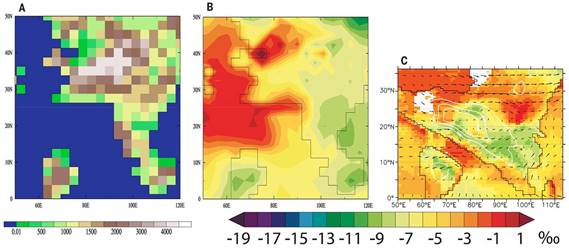
Fig. 1 Maps of geography and calculated δ18O. (A) Paleogeographic reconstruction of the middle Eocene. (B) June through September (JJAS) precipitation–weighted δ18O using this reconstruction and the isotope-enabled HadCM3L climate model. (C) Comparable result from figure 2F of Botsyun et al (2019).
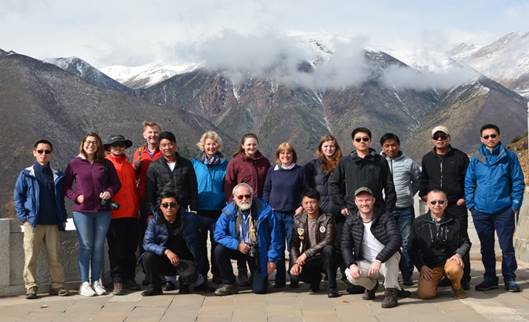
Fig. 2 Sino-British joint scientific examination team in the field work in southeastern Tibet
This work is supported by National Natural Science Foundation and the National Key Research and Development Project of China.Citation:Valdes, P.J., Lin, Ding, Farnsworth, A., Spicer, R.A., Li, S.-H., Tao, S., 2019. Comment on “Revised paleoaltimetry data show low Tibetan Plateau elevation during the Eocene”. Science, 365 (6459): eaax8474.
Reference:Botsyun, S., Sepulchre, P., Donnadieu, Y., et al., 2019. Revised paleoaltimetry data show low Tibetan Plateau elevation during the Eocene. Science, 363 (6430): eaaq1436.