

On July 28, Professor Ding Lin from the Institute of Tibetan Plateau Research, Chinese Academy of Sciences published the review paper in the name of "Timing and mechanisms of Tibetan Plateau uplift" upon the invitation of Springer Nature's professional academic journal Natural Review: Earth & Environment to review the rising history and its related dynamic mechanism of Tibetan Plateau. This review has systematically explained the differential uplift process and its related deep dynamic mechanism of the Tibetan Plateau since the Cretaceous.
The uplift of the Tibetan Plateau driven by the deep-spheres is one of the most important Cenozoic geological events in the world. Plateau uplift significantly affected the coupling processes of the earth system, including the atmosphere, cryosphere/hydrosphere, biosphere and anthroposphere, changed climate dynamic, biodiversity, carbon cycle, water resources and river evolution in Asia, which make the Tibetan Plateau the frontier of earth system scientific research in the 21st century.
However, the mechanisms of continental lithospheric deformation and spatial and temporal changes in surface elevation on the Tibetan Plateau during India-Asia continental collision are still unclear. In recent years, with the accelerated generation of quantitative paleoelevation data, scholars have gradually recognized that the plateau is characterized by differential uplift, and the uplift time in some areas is either earlier or later than previously assumed, and none of the existing dynamical models can fully reflect the uplift process of the plateau (Figure 1)

Figure 1. Digital elevation map and cross-section of the Himalaya and Tibetan Plateau.
Cretaceous tectonism and initial mountain growth
“A complete evolutionary model of the Tibetan Plateau must take into account the heterogeneity of paleogeomorphology and lithospheric heterogeneity from Asia during tectonic events prior to the Indo-Asian collision, which is essential for understanding the differential uplift of the plateau.” Just as Professor Ding Lin said.
Through detailed analysis of Cretaceous sea-land conversion, tectonic deformation, magma and low-temperature thermochronological evidence on the Tibetan Plateau, the research team proposes that the collision of the Lhasa-Qiangtang terrane and subsequent northward subduction of the Lhasa lithosphere led to the initial growth of the Watershed Mountains; the continued subduction of the Neo-tethys Oceanic slab uplifted the Gangdese Mountains above sea level at ~ 95 million years ago, just as the formation of present the Andes, thus called Andean-type Gangdese Mountains, and formed a significant precipitation effect in the southern Tibet. At this time, there were only two narrow mountain ranges in Tibet, the Watershed and Gangdese Mountains, but the magnitude of surface uplift remains to be quantified.
Time and Mode of Initial India-Asia collision
The timing and mode of the collision of the Indo-Asian plates are crucial for limiting the amount of Cenozoic intracontinental convergence, and also is the key to constrain the magnitude of surface uplift and deep dynamics of the plateau.
Current hypotheses for the closure history of the Neo-tethys Ocean include the Great Indian Basin model (Fig. 2a), the intra-oceanic subduction model (Fig. 2c-d), and the single-stage subduction-collision model (Fig. 2d). These hypotheses make very different predictions about the size of the Great India (the part of India that has subducted and disappeared beneath the Tibetan Plateau) and the timing of the initial India-Eurasia collision. However, all of these models are based on one key evidence first discovered by Ding Lin's team, the foreland basin formed by the India-Eurasia collision, which began to receive provenance from the Gangdese arc region 65 to 59 million years ago, indicating that the India-Eurasia collision had already begun by this time. This is much earlier than the previously internationally accepted time of initial collision between India and Eurasia, which was only 50 million years ago.
At the same time, the team's work in Tibet, Pakistan, and India over the past 20 years has also yielded key insights: 1. the Gangdese magmatic arc, pre-arc basins, ophiolites, and trenches currently developing in southern Tibet formed in an ocean-land subduction system at the southern margin of the Lhasa body, rather than in an intra-ocean subduction system far from the continent; 2. evidence from northern Pakistan suggests that Asian material could have reached the Indian subcontinent about 52 million years ago, not support the existence of an ocean basin prior to the India-Asia collision. Therefore, the review points out that the single-stage subduction-collision model is the simplest and the one supported by geological evidence to explain the India-Asia collision. Unfortunately, paleomagnetic data suggest that if the India-Eurasia collision occurred ~60 million years ago, the Indian and Asian continental lithosphere would have had to absorb ~4000 km of crustal shortening in a fully continental environment. However, current geological evidence suggests less than 2000 km of crustal shortening in Asia (<1000 km) and the Himalaya (<1000 km). To reconcile the mismatch between crustal shortening and the amount of paleomagnetic convergence, international scholars have proposed the Great Indian Ocean Basin model and the intra-oceanic subduction model (Fig. 2a-c), but both of these models currently lack the support of geological evidence. In addition, if the Indian continent has undergone a counterclockwise rotation of about ~90 degrees during the northward drift, it can also simply absorb the 2000 km latitudinal shortening.
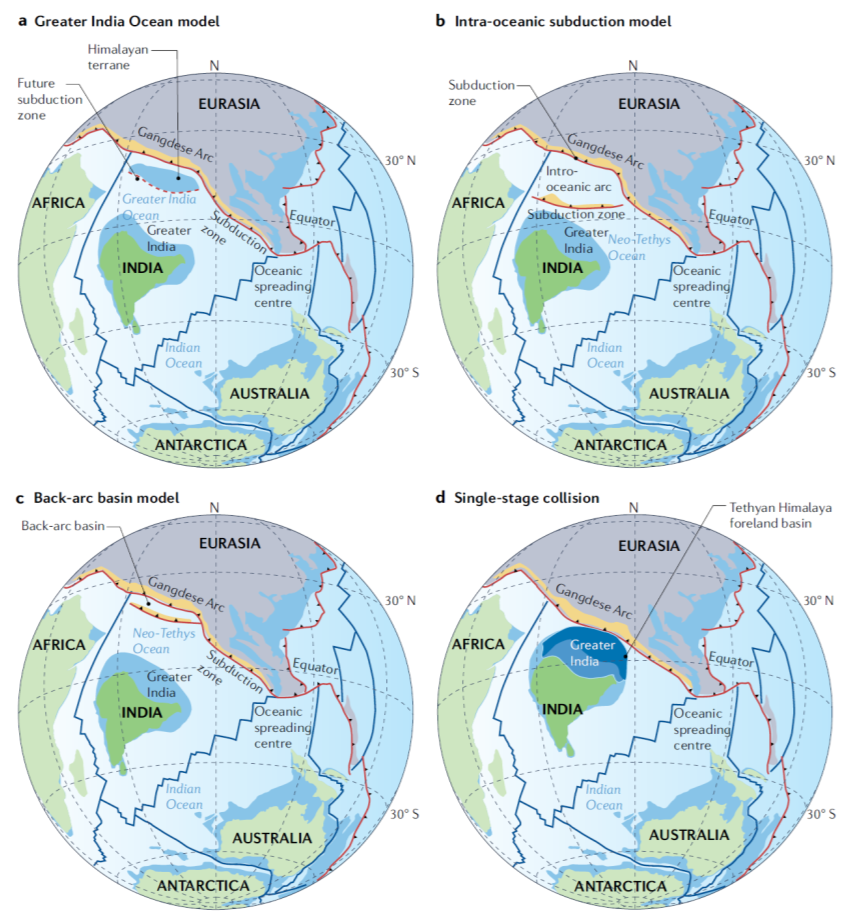
Figure 2. Competing hypotheses for the history of India–Asia suturing.
Cenozoic differential uplift history of the Tibetan Plateau and its dynamic mechanism
The need to address the history of plateau uplift has greatly contributed to the development of paleoaltimeters, and widely used quantitative paleoaltimetric proxies include hydrogen/oxygen isotopes, fossil plants and animals, and clumped isotopes. These quantitative proxies provide key information for continental deformation and plateau growth, and can provide a clearer understanding of the differential uplift process and dynamical mechanism of the plateau.
Combining the available quantitative paleolatitude results and deep dynamical evidence, the research team further recovered the surface uplift history (Figure 3) and lithospheric evolution (Figure 4) of the Tibetan Plateau from about 60 million years ago to the present day, suggesting that the different orogenic belts of the Tibetan Plateau have different uplift histories. ~45-40 million years ago, after the breakoff of the Neo-Tethys Ocean plate, the more buoyant Indian lithosphere wedged northward horizontally, activating the suture zone in the north and south of the Qiangtang body to undergo intra-subduction, causing the Watershed Mountains to rise to a high altitude of 5000 m. At this time, the Central Tibetan Valley between the Gangdese Mountains and the Watershed Mountains, the Himalaya Mountain in the south and the northern Tibet remained at low elevation. The paleotopography of the Tibet presented as “Two high mountains sandwiched a low land valley”. ~40-30 million years ago, the Lhasa lithosphere was dismantled below the Central Tibetan Valley, and a variety of coupled deep geodynamic processes, such as the shortening of the upper crust, magma inflation and upwelling, make the Central Tibetan Valley uplifted to 4500 m. ~25-15 million years ago, due to the continuous subduction of the Indian continent, the Indian continental lithosphere subducted beneath the Himalaya and the Asian continental lithosphere subducted beneath the Kunlun Mountains in northern Tibet were successively subducted, and the Himalayas and Kunlun Mountains were successively uplifted to their modern heights, and the plateau in the modern sense was formed (Figure 3). However, the uplift history of the northern region is still uncertain and needs to be verified by more quantitative paleo-altitude data.
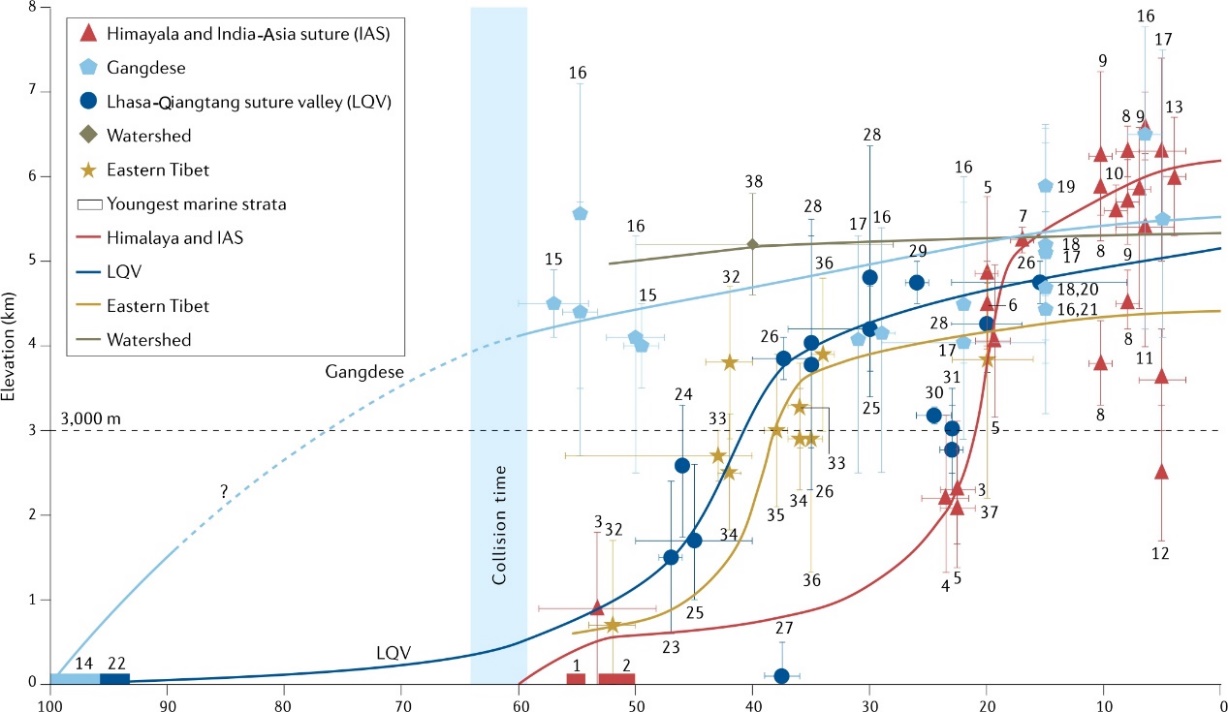
Figure 3. History of surface elevation change across Tibet.

Figure 4. Lithosphere-scale tectonic processes and corresponding changes in surface elevation and climate.
Present day India underthrusting
Geophysical evidences reveal that the present-day Indian and Eurasian lithosphere underwent various geodynamic behaviors ranging from horizontal wedging to steep subduction, plate tearing, breaking and delamination (Figure 5), indicating that similar processes occurred continuously throughout the Cenozoic India-Asia continental collision, culminating in the spatial and temporal variability of tectonic deformation, magmatism, and surface uplift of the Tibetan Plateau.

Figure 5. Modern geometries of subducting Indian and Asian lithosphere
To address the timing and mechanism of the uplift of the Tibetan Plateau, the review points out that the future research directions to be focused on include: 1. resolve the inconsistency between the amount of Indo-Asian convergence and crustal shortening; 2. require large amounts of high-resolution paleoelevation data to accurately define the history of plateau uplift; 3. combine numerical simulations and geological data to accurately reconstruct the evolutionary history of the plateau Earth system; 4. combine geophysical imaging techniques and geodynamic simulations to elucidate the circulation processes and distribution of the continental lithosphere, and analyze how continental collisions affect the tectonics of adjacent plate boundaries and mantle convection on a global scale.
The research results were jointly funded by the Second Tibetan Plateau Scientific Expedition and Research (2019QZKK0708), Basic Science Center for Tibetan Plateau Earth System (41988101), and the Chinese Academy of Sciences "Silk Road Environment" (XDA20070301).
Paper information:Lin Ding *, Paul Kapp, Fulong Cai*, Carmala Garzione, Zhongyu Xiong, Houqi Wang, Chao Wang. Timing and mechanisms of Tibetan Plateau uplift. Nature Review Earth&Environment.