| News |
| Latest news | |
| Int’l Cooperation activities | |
| Events & Announcement | |
| Recent Activities |
| Location: Home>News>Recent Activities |
| STE: Evaluation of new MODIS daily NDSI snow cover product version 6 across China: which NDSI threshold should be used? |
Compared with the limited amount of in situ measurements of snow depth or snow water equivalent (SWE) that are usually provided by sparse meteorological stations, satellite-based snow cover estimates have the potential to produce spatiotemporal patterns of snow cover at a larger scale. Among various such products, MODIS snow cover product is the most widely used. It is produced based on the Normalized Difference Snow Index (NDSI) to distinguish snow from other land cover types that those with NDSI ≥ the NDSI threshold are considered as snow covered. NASA has recently published MODIS snow cover product version 6 (V6) to replace V5, with significant revisions including: (1) a restored band 6 is in place of the previously used band 7 in the calculation of NDSI for Aqua; (2) In v5, the pixels with surface temperature greater than 283 K are considered as snow-free pixels, whereas V6 considers the effects of elevation that for locations with altitudes ≥ 13 00 m, the “snow” pixels with surface temperature ≥ 283 K will not be reversed but be flagged as “warm snow”; (3) the most important one is that the binary and fractional snow cover estimates are no longer available and only the NDSI is provided. Several studies have used 0 as the NDSI threshold to calculate snow cover since V6 was released, because positive NDSI indicates there is some snow present in the pixel in the opinion of G.A. Riggs and others who are the main authors of V6. However, the minimum valid NDSI of V6 is actually 0.1. As is well known to all, that of V5 is 0.4. Focusing on how to select a reasonable NDSI threshold for use of V6 in China, Dr. Hongbo Zhang, a member of Professor Fan Zhang’s team of the CAS center for excellence in Tibetan Plateau earth sciences and the Institute of Tibetan Plateau Research, and the co-authors evaluated the accuracy of V6 in China and compared it with V5, using 3 kinds of NDSI thresholds and 6 types of evaluation metrics, based on the snow depth observations from more than 200 meteorological stations.
Figure 1. Study site.
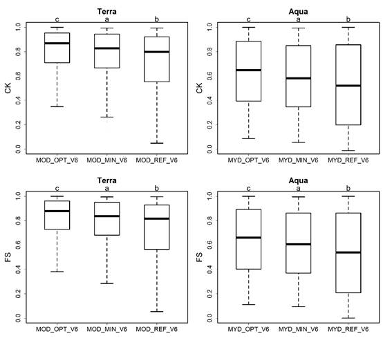
Figure 2. Comparison of station-based accuracies (CK in upper part and FS in lower part) from the three different NDSI threshold schemes for Terra (left) and Aqua (right) based on paired t-tests. CK:Cohen’s Kappa;FS:F-score. Letters at the top indicate the significance of the differences: the schemes with a same letter at the top indicate insignificant difference. The box and whiskers show the distributions of station-based metrics.
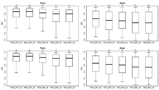
Figure 3. Comparison of station-based accuracies (CK in upper part and FS in lower part) from the five different NDSI threshold schemes of products V5 and V6 for Terra (left) and Aqua (right) based on paired t-tests. CK:Cohen’s Kappa;FS:F-score. Letters at the top indicate the significance of the differences: the schemes with a same letter at the top indicate insignificant difference. The x axis is in order of the average CK or FS. The box and whiskers show the distributions of station-based metrics.
Figure 4. Comparison of validation accuracies including the CK, FS, RC, PC and OA between stations within the Tibetan Plateau (TP) and those outside the TP. CK:Cohen’s Kappa;FS:F-score;RC: recall; PC: precision; OA: overall accuracy The study was supported by the National Natural Science Foundation of China (Grant No. 41701079, 41771090 and 41761144078) and China Postdoctoral Science Foundation (2017M620069 and 2017M611013), and has been published in Science of the Total Environment, titled “Ground-based evaluation of MODIS snow cover product V6 across China: Implications for the selection of NDSI threshold”, with paper link: https://www.sciencedirect.com/science/article/pii/S0048969718340099 。 |